
Qingshankou Fm
Type Locality and Naming
Songliao Basin. The Qingshankou Formation was erected by the Second Petroleum Prospecting Brigade under the Ministry of Geology in 1958 and was then publically used by Si Xingjian and Zhou Zhiyan in 1962. The section for the designation is at Qingshankou on the southern bank of the second Songhuajiang River about 70 km northeast of the Nong’an County of Jilin. The reference section is down the well No. du-402 in Monggol Autonomous county of Dorbod of Heilongjiang. Lower-middle formation (3 of 7) in the Songhuajiang Gr.
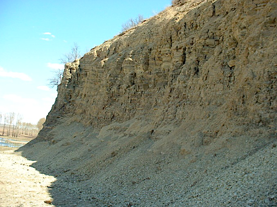
[Figure: Type section of Qingshankou Formation at Qingshankou Village, Nong’an County of Jilin]
Lithology and Thickness
The Qingshankou Formation is represented by a set of black and green sandy mudstone, which is divided in ascending order into three members. First member is built up by gray black mudstone, silty mudstone and oil shale. Second and Third members are built up by gray and gray black mudstone, calcareous siltstone and ostracod-bearing beds, occasionally with biotic limestone. The Qingshankou Formation is 183 m thick. It is a major oil-bearing formation throughout the Songliao basin.
[Figure: Qingshankou Formation at Lijiatuozi section of Qingshankou Village, Nong’an County of Jilin]
Relationships and Distribution
Lower contact
The base of the formation marked by 20 m gray black mudstone with black brown oil shale is bounded by the underlying Quantou Fm marked by gray green mudstone. The contact is conformable.
Upper contact
The top marked by gray mudstone is distinguished from the overlying Yaojia Fm marked by grayish brown calcareous siltstone and fine sandstone. The contact is conformable.
Regional extent
It is widespread in the Songliao basin. In the Baichengzi area of Jilin, it is bounded by the line linking Baicheng-Shuanggang-Shengli and gradually thins out westward. It is represented by grayish green siltstone, fine sandstone, gravel-bearing sandstone, and small amounts of granule conglomerate and brownish red mudstone, with a maximum thickness of 200 m. in the area south of the line linking the Liangjia railway station, Heidimiao and Fulongquan of Changling, there appear a lot of clastic rocks, and quite a lot of brownish red and grayish green mudstone are intercalated in the middle and upper parts of the formation. To the west of the line linking Yushu, Changchun and Gongzhuling , it is dominated by brownish red mudstone. In Huaide and Shuangchengbao, it becomes coarser in lithology, without oil shale, generally measuring 300 m in thickness. The formation outcrops in Wukeshu of the Yushu County, Qingshankou of the Nongan County, Denglouku of the Qian Gorlos, Erdaogou of the Jiutai County, and Shangendi of the Huaide County. The first member is basically the same in lithology throughout Heilongjiang and increases in the amount of sandstone, and becomes coarser in grain size, where appear red mudstone. The formation is generally 30-80 m thick towards the margin of the basin in the northern part. The second and third members vary considerably both in lithology and thickness, and are built up by gray and grayish green mudstone and sandy mudstone with siltstone and fine-grained calcareous sandstone. In Nangnangxi-Taikang in the western part, ostracod limestone is observed and there appear red mudstone in the northern and eastern parts. The formation is 400-500 m in the central depression, 130-170 m in the northern part, 240-323 m in the central depression near the northern part, 130-160 m in Keshan-Beian towards north, and generally 53-124 m in the western part.
GeoJSON
Fossils
The formation bears ostracods Triangulicypris torsuosus, Cypridea (Morinis) dekheinensis, C. (M.) adumbrata, Ziziphocypris simakovi; estherias Ellipsogiapta elliptica, Nemestheria qingshankouensis; down the well No.Du-405 floras Celastrophyllum sp., Saliciphyllum sp.; bivalves Martinsonella paucisulcata; down the well No.Jing-15, the Cyathidites- Pinuspollenites-Tricolporopollenites assemblage.
Age
Depositional setting
It is of lake shore, shallow lacustrine and relatively deep lacustrine deposition.
Additional Information
Enhanced with Igor N. Kosenko, Jingeng Sha and Boris N. Shurygin (2021). Upper Mesozoic stratigraphy of Sikhote-Alin (Russian Far East) and northeastern China: Non-marine and marine correlations. Part 1: Upper Jurassic-Hauterivian AND 2. Barremian-Aptian. Cretaceous Research, 124: articles 104811 (https://doi.org/10.1016/j.cretres.2021.104811) AND 104812 (https://doi.org/10.1016/j.cretres.2021.104812)